Popular Posts
-
 http://www.youtube.com/watch?v=-H0_vlUheyc&feature=player_embedded அமல னாதிபிரா னடியார்க் கென்னை யாட்படுத்த விமலன் , விண்ண...
 -
வார்த்தைகளால் வர்ணிக்க முடியாத கொடைக்கானல் வார்த்தைகளால் வர்ணிக்க முடியாத இயற்க்கையின் வண்ணக் கோலம் கொடைக்கானல். 2133 மீட்டர் உயரத்தில் உ...
-
முக்கடலும் சங்கமிக்கும் கன்னியாகுமரி [ Tues, Aug 24, 2010, 04:55 pm ] பரப்பளவு - 4,433 சதுர கி.மீட்டர் சென்னையிலிருந்து 7...
-
 அழியாத எழிலோவியம் - அஜந்தா இந்தியாவின் மகாராஷ்டிரா மாநிலத்தின் அஜந் தா எனும் ஊரில் உள்ள குகைகளில் இயற்கை முறையில் வரைந்தஓவியங்...
 -
 Himalaya Beauty Himalaya Beauty The Himalaya is a mountain range in Asia, separating the Indian subcontinent from the Tibetan Plate...
 -
 Aamby Valley City [India] A amby Valley City is the first of its kind Megalopolis, spread over more than ten thousand undulating acres of v...
 -
 தஞ்சைப் பெரிய கோயில்: ஆயிரம் ஆண்டு அற்புதம் 25 Sep 2010 தஞ்சாவூர் வரலாற்று முக்கியத்துவம் வாய்ந்த சோழர்களின் தலைநகரம். இங்குதான் கடைச்...
 -
 Indonesia The Republic of Indonesia, the world's fourth most populous nation, has 203 million people living on nearly one thousand per...


Tuesday, August 10, 2010
அழியாத எழிலோவியம் - அஜந்தா
அழியாத எழிலோவியம் - அஜந்தா


Ajanta Caves (Devanagari:अजंठा लेणी) in Maharashtra, India are rock-cut cave monuments dating from the second century BCE, containing paintings and sculpture considered to be masterpieces of both “Buddhist religious art” and “universal pictorial art”. The caves are located just outside the village of Ajinha in Aurangabad District in the Indian state of Maharashtra (N. lat. 20 deg. 30′ by E. long. 75 deg. 40′). Since 1983, the Ajanta Caves have been a UNESCO World Heritage Site. A National Geographic edition reads, “The flow between faiths was such that for hundreds of years, almost all Buddhist temples, including the ones at Ajanta, were built under the rule and patronage of Hindu kings.”

Get In


The caves are in a wooded and rugged horseshoe-shaped ravine about 3½ km from the village of Ajantha. It is situated in the Aurangābād district of Maharashtra State in India (106 kilometers away from the city of Aurangabad). The nearest towns are Jalgaon (60 kilometers away) and Bhusawal (70 kilometers away). Along the bottom of the ravine runs the river Waghur, a mountain stream. There are 29 caves (as officially numbered by the Archaeological Survey of India), excavated in the south side of the precipitous scarp made by the cutting of the ravine. They vary from 35 to 110 ft (34 m) in elevation above the bed of the stream.

History


The monastic complex of Ajanta consists of several viharas (monastic halls of residence) and chaitya-grihas (stupa monument halls) cut into the mountain scarp in two phases. The first phase is mistakenly called the Hinayana phase (referring to the Lesser Vehicle tradition of Buddhism, when the Buddha was revered symbolically). Actually, Hinayana – a derogative term for Sthaviravada – does not object to Buddha statues. At Ajanta, cave numbers 9, 10, 12, 13, and 15A (the last one was re-discovered in 1956, and is still not officially numbered) were excavated during this phase. These excavations have enshrined the Buddha in the form of the stupa, or mound.

By AD 480 the caves at Ajanta were abandoned. During the next 1300 years the jungle grew back and the caves were hidden, unvisited and undisturbed until the Spring of 1819 when a British officer in the Madras army entered the steep gorge on the trail of a tiger. Somehow, deep within the tangled undergrowth, he came across the almost hidden entrance to one of the caves. Exploring that first cave, long since a home to nothing more than birds and bats and a lair for other, larger, animals, Captain Smith wrote his name in pencil on one of the walls. Still faintly visible, it records his name and the date, April 1819.


Paintings

Paintings are all over the cave except for the floor. At various places the art work has become eroded due to decay and human interference. Therefore, many areas of the painted walls, ceilings, and pillars are fragmentary. The painted narratives of the Jataka tales are depicted only on the walls, which demanded the special attention of the devotee. The process of painting involved several stages. The first step was to chisel the rock surface, to make it rough enough to hold the plaster. The plaster was made of clay, hay, dung and lime. Differences are found in the ingredients and their proportions from cave to cave. While the plaster was still wet, the drawings were done and the colors applied. The wet plaster had the capacity to soak the color so that the color became a part of the surface and would not peel off or decay easily.


The colors were referred to as ‘earth colors’ or ‘vegetable colors.’ Various kinds of stones, minerals, and plants were used in combinations to prepare different colors. Sculptures were often covered with stucco to give them a fine finish and lustrous polish. The stucco had the ingredients of lime and powdered seashell or conch. The latter afforded exceptional shine and smoothness. In cave upper six, some of it is extant. The smoothness resembles the surface of glass. The paint brushes used to create the artwork were made from animal hair and twigs.


Scholars disagree about the date of the Ajanta Caves' second period. For a time it was thought that the work was done over a long period from the fourth to the seventh century AD, but recently long-time researcher Walter M. Spink declared that most of the work took place over short time period, from 460 to 480 AD, during the reign of Emperor Harishena of the Vakataka dynasty. Some 20 cave temples were simultaneously created, for the most part viharas: monasteries with a sanctuary in the structure's rear centre. Each of cave temples seem to be patronised by influential authority, numerous best available artists have been involved in the work with fruitful rivalry between the neighbouring construction sites.[3]
According to Spink, Ajanta Caves seem to be abandoned shortly after the fall of Harishena circa 480 AD. Since then these temples have been abandoned and gradually forgotten. During the next 1300 years the jungle grew back and the caves were hidden, unvisited and undisturbed.
http://www.powershow.com/view/


இந்தியாவின் மகாராஷ்டிரா மாநிலத்தின் அஜந்தா எனும் ஊரில் உள்ள குகைகளில் இயற்கை முறையில் வரைந்தஓவியங்களே அஜந்தா ஓவியங்களாகும். இவை கிமு 200 முதல் கிபி 650 வரையான பல்வேறுபட்ட காலப்பகுதியில் வரைந்தவை. பௌத்த மதக் கொள்கைகளை முதன்மைப்படுத்தி இந்த ஓவியங்கள் வரைந்தவையாகும்.

Ajanta Caves (Devanagari:अजंठा लेणी) in Maharashtra, India are rock-cut cave monuments dating from the second century BCE, containing paintings and sculpture considered to be masterpieces of both “Buddhist religious art” and “universal pictorial art”. The caves are located just outside the village of Ajinha in Aurangabad District in the Indian state of Maharashtra (N. lat. 20 deg. 30′ by E. long. 75 deg. 40′). Since 1983, the Ajanta Caves have been a UNESCO World Heritage Site. A National Geographic edition reads, “The flow between faiths was such that for hundreds of years, almost all Buddhist temples, including the ones at Ajanta, were built under the rule and patronage of Hindu kings.”

Get In


History

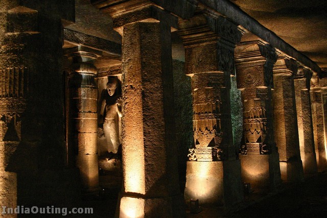

By AD 480 the caves at Ajanta were abandoned. During the next 1300 years the jungle grew back and the caves were hidden, unvisited and undisturbed until the Spring of 1819 when a British officer in the Madras army entered the steep gorge on the trail of a tiger. Somehow, deep within the tangled undergrowth, he came across the almost hidden entrance to one of the caves. Exploring that first cave, long since a home to nothing more than birds and bats and a lair for other, larger, animals, Captain Smith wrote his name in pencil on one of the walls. Still faintly visible, it records his name and the date, April 1819.


Paintings

Paintings are all over the cave except for the floor. At various places the art work has become eroded due to decay and human interference. Therefore, many areas of the painted walls, ceilings, and pillars are fragmentary. The painted narratives of the Jataka tales are depicted only on the walls, which demanded the special attention of the devotee. The process of painting involved several stages. The first step was to chisel the rock surface, to make it rough enough to hold the plaster. The plaster was made of clay, hay, dung and lime. Differences are found in the ingredients and their proportions from cave to cave. While the plaster was still wet, the drawings were done and the colors applied. The wet plaster had the capacity to soak the color so that the color became a part of the surface and would not peel off or decay easily.


The colors were referred to as ‘earth colors’ or ‘vegetable colors.’ Various kinds of stones, minerals, and plants were used in combinations to prepare different colors. Sculptures were often covered with stucco to give them a fine finish and lustrous polish. The stucco had the ingredients of lime and powdered seashell or conch. The latter afforded exceptional shine and smoothness. In cave upper six, some of it is extant. The smoothness resembles the surface of glass. The paint brushes used to create the artwork were made from animal hair and twigs.


Scholars disagree about the date of the Ajanta Caves' second period. For a time it was thought that the work was done over a long period from the fourth to the seventh century AD, but recently long-time researcher Walter M. Spink declared that most of the work took place over short time period, from 460 to 480 AD, during the reign of Emperor Harishena of the Vakataka dynasty. Some 20 cave temples were simultaneously created, for the most part viharas: monasteries with a sanctuary in the structure's rear centre. Each of cave temples seem to be patronised by influential authority, numerous best available artists have been involved in the work with fruitful rivalry between the neighbouring construction sites.[3]
According to Spink, Ajanta Caves seem to be abandoned shortly after the fall of Harishena circa 480 AD. Since then these temples have been abandoned and gradually forgotten. During the next 1300 years the jungle grew back and the caves were hidden, unvisited and undisturbed.
http://www.powershow.com/view/

Saturday, August 7, 2010
Palace city
Udaipur

Udaipur City Palace is one of the architectural marvels of Rajasthan, located peacefully on the banks of Lake Pichola. This majestic City Palace is the most-visited tourist attraction of Udaipur and often distinguished as the largest palace complex in Rajasthan. Initially, Maharana Udai Singh built this superb wonder, but the present form of the Palace is the result of subsequent additions by his successors.

City Palace boasts of the wonderful blend of Medieval, European and Chinese Architecture. The Palace has various towers, domes and arches, which add to the flavor of heritage site. Towering on the banks of Pichola Lake, City Palace is truly a feast to the eyes. City Palace is a marvelous assortment of courtyards, pavilions, terraces, corridors, rooms and hanging gardens. Encircled by fortifications, this imposing Palace is wholly built in granite and marble.

City Palace has several gates that are known as "Pols". 'Bara Pol' (Great Gate) is the main gate to the City Palace complex that will take you to the first courtyard. On passing 'Bara Pol', you will come across a triple arched gate, which is known as 'Tripolia'. Between these two gates, you would see eight marble arches or Toranas, where Kings used to weigh themselves with gold and silver. Besides Tripolia, there is an arena where elephant fights were staged. Across 'Tripolia', you would enter the 'Elephant Gate' or the 'Hathi Pol'.

City Palace comprises 11 wonderful palaces, which were built by different rulers still they resemble each other. With the sheer glimpse of unique paintings, antique furniture and exquisite glass mirror & ornamental tiles work of these palaces, you will get amazed. Manak Mahal (Ruby Palace) has figures of crystal and porcelain. However, Bhim Vilas flaunts a fabulous collection of miniature paintings depicting the real life stories of Radha-Krishna.

The 'Krishna Vilas' is known for the noteworthy album of miniature paintings portraying royal processions, festivals and games of the Maharanas. Moti Mahal (Pearl Palace) is celebrated for its lavish decor while Sheesh Mahal (Palace of mirrors) is known for its breathtaking mirror work. 'Chini Chitrashala' is renowned for its Chinese and Dutch ornamental tiles. 'Dilkusha Mahal' (Palace of Joy) is known for the murals and wall paintings.

Bada Mahal is the exotic garden palace that stands erect on a 90 feet high natural rock formation. Rang Bhawan is the palace that used to contain royal treasure. There are temples of Lord Krishna, Meera Bai and Shiva, located right to the 'Rang Bhawan'. 'Mor Chowk' has exceptional glass mosaics of peacocks, set in the walls presenting the three seasons of summer, winter and monsoon. 'Laxmi Vilas Chowk' is an art gallery with a distinctive collection of Mewar paintings.

Situated in the premises of City Place complex, Jagdish Temple is the biggest and most beautiful temple of Udaipur. This temple Appeals to the aesthetic sense of the people and we will further discuss it in our other section. You can also trace a Shrine of Dhuni Mata in the complex of City Palace. This part is considered as the oldest part of the Palace where a sage passed his life meditating here.

In 1974, a part of the City Palace and the 'Zenana Mahal' (Ladies Chamber) have been transformed into a museum. The museum is open for public and we have discussed it in our other section about museums. One can locate some striking paintings in the 'Zenana Mahal' which further leads to Lakshmi Chowk. 'Lakshmi Chowk' is a beautiful white pavilion. In City palace, the most captivating sight can be viewed from the towers and terraces of 'Amar Vilas' from where you can get a breathtaking view of Lake Pichola.

'Amar Vilas' is the highest point of this Palace and has wonderful hanging gardens with fountains, towers and terraces. City Palace is structured in a way that it offers a splendid view of the lake from all its Balconies, cupolas and towers. Unlike the craggy exterior, City Palace has amazing interiors with delicate mirror-work, marble work, murals, wall paintings, silver work, inlay work and surplus of colored glass. The exquisite work of City Palace cannot be bounded in words, so one must visit this palace to capture the real picture of it.


Friday, August 6, 2010
Chand Baori - The Deepest Stepwell in the World.
Chand Baori is a famous stepwell situated in the village Abhaneri near Jaipur in Indian state of Rajasthan.
The Chand Baori, a vast well with flights of steps on three sides, is a 10th century monument situated in Abhaneri.
It is a fine example of the architectural excellence prevalent in the past. This impressive step well is as deep as a seven storeyed building.
The famous Harshat Mata temple situated opposite to this well shows that there must have been a religious connection with the step-well. The well is 35 meter on each side with steps leading down from each side and water can be drawn from any level. It has so many steps to make it impossible for someone to retrieve a coin once it has been dropped in the well.


Chand Baori is a famous stepwell situated in the village Abhaneri near Jaipur in Indian state of Rajasthan.
The Chand Baori, a vast well with flights of steps on three sides, is a 10th century monument situated in Abhaneri.
It is a fine example of the architectural excellence prevalent in the past. This impressive step well is as deep as a seven storeyed building.
The famous Harshat Mata temple situated opposite to this well shows that there must have been a religious connection with the step-well. The well is 35 meter on each side with steps leading down from each side and water can be drawn from any level. It has so many steps to make it impossible for someone to retrieve a coin once it has been dropped in the well.


Wednesday, August 4, 2010
Indonesia
Indonesia
The Republic of Indonesia, the world's fourth most populous nation, has 203 million people living on nearly one thousand permanently settled islands. Some two-to-three hundred ethnic groups with their own languages and dialects range in population from the Javanese (about 70 million) and Sundanese (about 30 million) on Java, to peoples numbering in the thousands on remote islands. The nature of Indonesian national culture is somewhat analogous to that of India - multicultural, rooted in older societies and interethnic relations, and developed in twentieth century nationalist struggles against a European imperialism that nonetheless forged that nation and many of its institutions. The national culture is most easily observed in cities but aspects of it now reach into the countryside as well. Indonesia's borders are those of the Netherlands East Indies, which was fully formed at the beginning of the twentieth century, though Dutch imperialism began early in the seventeenth century. Indonesian culture has historical roots, institutions, customs, values, and beliefs that many of its people share, but it is also a work in progress that is undergoing particular stresses at the beginning of the twenty-first century.
The name Indonesia, meaning Indian Islands, was coined by an Englishman, J. R. Logan, in Malaya in 1850. Derived from the Greek, Indos (India) and nesos (island), it has parallels in Melanesia, "black islands"; Micronesia, "small islands"; and Polynesia, "many islands." A German geographer, Adolf Bastian, used it in the title of his book, Indonesien , in 1884, and in 1928 nationalists adopted it as the name of their hoped-for nation.
Most islands are multiethnic, with large and small groups forming geographical enclaves. Towns within such enclaves include the dominant ethnic group and some members of immigrant groups. Large cities may consist of many ethnic groups; some cities have a dominant majority. Regions, such as West Sumatra or South Sulawesi, have developed over centuries through the interaction of geography (such as rivers, ports, plains, and mountains), historical interaction of peoples, and political-administrative policies. Some, such as North Sumatra, South Sulawesi, and East Java are ethnically mixed to varying degrees; others such as West Sumatra, Bali, and Aceh are more homogeneous. Some regions, such as South Sumatra, South Kalimantan, and South Sulawesi, share a long-term Malayo-Muslim coastal influence that gives them similar cultural features, from arts and dress to political and class stratification to religion. Upland or upriver peoples in these regions have different social, cultural, and religious orientations, but may feel themselves or be perforce a part of that region. Many such regions have become government provinces, as are the latter three above. Others, such as Bali, have not.


The Republic of Indonesia, the world's fourth most populous nation, has 203 million people living on nearly one thousand permanently settled islands. Some two-to-three hundred ethnic groups with their own languages and dialects range in population from the Javanese (about 70 million) and Sundanese (about 30 million) on Java, to peoples numbering in the thousands on remote islands. The nature of Indonesian national culture is somewhat analogous to that of India - multicultural, rooted in older societies and interethnic relations, and developed in twentieth century nationalist struggles against a European imperialism that nonetheless forged that nation and many of its institutions. The national culture is most easily observed in cities but aspects of it now reach into the countryside as well. Indonesia's borders are those of the Netherlands East Indies, which was fully formed at the beginning of the twentieth century, though Dutch imperialism began early in the seventeenth century. Indonesian culture has historical roots, institutions, customs, values, and beliefs that many of its people share, but it is also a work in progress that is undergoing particular stresses at the beginning of the twenty-first century.
The name Indonesia, meaning Indian Islands, was coined by an Englishman, J. R. Logan, in Malaya in 1850. Derived from the Greek, Indos (India) and nesos (island), it has parallels in Melanesia, "black islands"; Micronesia, "small islands"; and Polynesia, "many islands." A German geographer, Adolf Bastian, used it in the title of his book, Indonesien , in 1884, and in 1928 nationalists adopted it as the name of their hoped-for nation.
Most islands are multiethnic, with large and small groups forming geographical enclaves. Towns within such enclaves include the dominant ethnic group and some members of immigrant groups. Large cities may consist of many ethnic groups; some cities have a dominant majority. Regions, such as West Sumatra or South Sulawesi, have developed over centuries through the interaction of geography (such as rivers, ports, plains, and mountains), historical interaction of peoples, and political-administrative policies. Some, such as North Sumatra, South Sulawesi, and East Java are ethnically mixed to varying degrees; others such as West Sumatra, Bali, and Aceh are more homogeneous. Some regions, such as South Sumatra, South Kalimantan, and South Sulawesi, share a long-term Malayo-Muslim coastal influence that gives them similar cultural features, from arts and dress to political and class stratification to religion. Upland or upriver peoples in these regions have different social, cultural, and religious orientations, but may feel themselves or be perforce a part of that region. Many such regions have become government provinces, as are the latter three above. Others, such as Bali, have not.


*BALI* Elaphant cave-1200 years old Picking coffee beans.
|
 This Protestant Church in Semarang was built by the Dutch community way back in 1753. Since then, every Sunday, the Gereja Blenduk Church comes alive to the sound of hymns and prayers In 1894 Semarang’s Gereja Blenduk Church underwent extensive renovation, under the guidance of W. Westmaas and H.P.A de Wilde.
  It is the architecture of the Gereja Blenduk Church that is its very interesting feature and it’s on this account that it’s visited by every tourist in Semarang. Blenduk means “dome” and the large copper dome of this beautiful church is one of its very notable features. Besides, the Gereja Blenduk Church in Semarang has other features characteristic of 18th architecture. The ground plan of this Church is structured on a Greek cross. It also has four pillars and a beautiful classical portico. When in 1894, the Church was being renovated the beauty of this Church was enhanced by the addition of two towers in front of it.
 The interiors of the Gereja Blenduk Church are original and haven’t ever been tampered with.You can still see the chairs used by the original congregation. A huge organ in the baroque style of the 18th century will capture your attention, as soon as you enter the Church.This organ is really fascinating because it goes back to the 18th century. It can neither be restored nor is it working and it remains as a silent spectator to the Church’s glorious history. Note the iron stairs that lead straight up to the organ specially constructed by Pletterji Den Haag.
  Once you’re done admiring the oldest Church in Central Java, you can tour Nillmi Building and the other buildings nearby built in Dutch colonial times that are equally worth a visit.
Subscribe to:
Posts (Atom)